
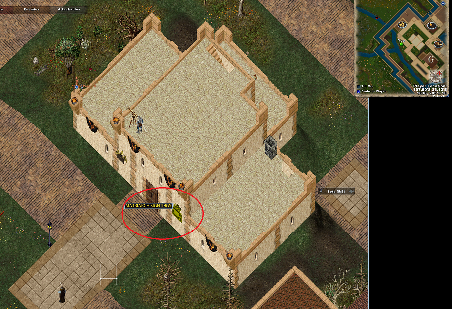
Publish122: matriarch sightings board to map location

The changes below will cause a double click on the matriarch sightings board to update the player radar/map with a waypoint placed for the matriarch, if it's active.
file GumpsParsing.lua, function GumpsParsing.ShowHide()
elseif (gumpID == 9111) then -- "matriarch sightings" gump
for label, data in pairs(GumpData.Gumps[gumpID].Labels) do
if( data.tid == nil or data.tid ~= 1164891 ) then
continue
end
if( data.tidParms == nil ) then
break
end
local senderText = ReplaceTokens(GetStringFromTid(data.tid), data.tidParms)
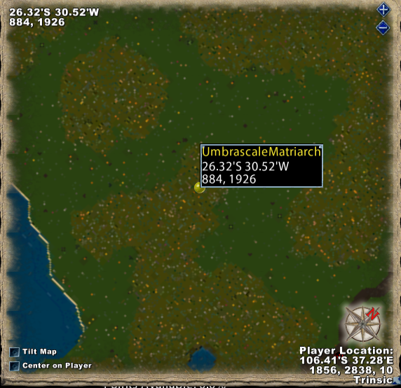
TextParsing.PlaceMapSpecialWaypoint( senderText, L"UmbrascaleMatriarch" )
break
end -- for
file TextParsing.lua, paste this as a new function at the bottom of the file:
function TextParsing.PlaceMapSpecialWaypoint( senderText, mobName )
	-- eg. 61o 32'N, 45o 8'W at Malas in Malas!
	-- eg. 107o 45'S, 17o 26'E at a location in the wilderness in Trammel! (town cryer order)
	-- eg. a forest outside Skara Brae at 26o 37'S, 30o 52'W in Trammel!   (treasure map hunter notification, flipped area order)
	local facet_number = nil
	local coord = wstring.match(senderText, L"%d+o%s%d+['][NS][,].*%d+o%s%d+['][EW]")	-- extract the coordinates per rigid syntax.  note ".*" search pattern at long/lat, appears there may be alternate whitespace/control character(s) in the middle.

	local latDir
	local latVal
	local longDir
	local longVal

	if( coord == nil ) then
		return
	end

	local text2 = wstring.find(coord, L"[,]")
	first = wstring.sub(coord, 1, text2-1)

	first = wstring.gsub(first, L"o ", L".")
	first = wstring.gsub(first, L"'", L"")

	latDir = wstring.sub(first, -1)
	latVal = wstring.sub(first,1, -2)

	local second = wstring.sub(coord, text2 + 2)
	second = wstring.gsub(second, L"o ", L".")
	second = wstring.gsub(second, L"'", L"")

	longDir = wstring.sub(second, -1)
	longVal = wstring.sub(second,1, -2)

	-- extract facet from end of string.

	local tail = wstring.len(senderText)

	local facet = wstring.sub(senderText, tail-7)	-- match on the last 8 characters.

	if(facet == nil) then
		return
	end


	local facets = {[L"Felucca!"]=0,
					[L"Trammel!"]=1,
					[L"lshenar!"]=2,
					[L"n Malas!"]=3,
					[L"Islands!"]=4,	-- (is "Tokuno Islands!")
					[L"Ter Mur!"]=5}
	facet_number = facets[facet]

	if( facet_number == nil ) then
		return
	end

	local x,y = MapCommon.ConvertToXYMinutes(tonumber(latVal), tonumber(longVal), latDir, longDir, 1, 1)

	if( x == nil or y == nil ) then
		return
	end

	-- TODO search for existing waypoint, return if exists.

	UOCreateUserWaypoint( MapCommon.WaypointCustomType, x, y, facet_number, mobName.. L"_ICON_100010_SCALE_" .. 1.00 )	-- was 0.69	was 1.50
	CenterScreenText.SendCenterScreenTexture("battlebegin")
	--Debug.PrintToChat(mobName..L" ".. towstring(x).. L","..towstring(y)..L" facet:".. towstring(facet_number))
	-- new code follows to switch the map to the facet in question, centered on the x,y coordinates.
	MapWindow.CenterOnPlayer = false
	ButtonSetPressedFlag( "MapWindowCenterOnPlayerButton", false )
	UORadarSetCenterOnPlayer( false )
	-- change map facet and center x,y position.
	UOCenterRadarOnLocation(x, y, facet_number, 0, false)
	MapCommon.UpdateZoomValues(facet_number, 0)
	MapCommon.AdjustZoom(0)
end